flox-GPU facts:
| Model | 2D-Shallow water equations |
| Conserved variables | water depth (h), Specific discharges in x- and y-direction (hu, hv) |
| Scheme | Finite-Volumes (FV), Central upwind scheme (shock-capturing), Minmod slope limiter |
| Accuracy | 2. order accuracy in space and time |
| Time integration | Explicit Runge-Kutta |
| Friction | Semi-implicit treatment of friction term (Strickler/Manning coefficient) |
| Mesh type | Structured mesh, quadratic cells |
| GPU | Single-Precision NVIDIA GPU |
| Hydraulic structures | Culverts, bridges |
| Boundary conditions | Reflective boundaries, outflow boundaries, inflow source |
| Initial conditions | Dry or wet domains, hot start from previous runs |
| Input / Output grid formats | Grids/meshes in common GIS formats supported by GDAL (*.tif, *.asc, etc.) |
| Output | Grids/images: – max. water depths, water level, velocities and intensities – water depths, velocities, Froude values, bed shear stress at specified time interval for specific regions – CFL numbers Measures at point locations/lines: – water depth, water level discharges Other: – Model summary and log – hot start files |
Input:
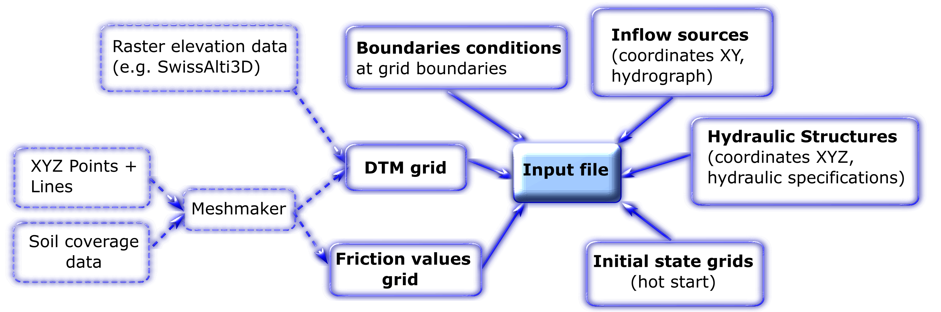 Input is specified in a simple text file (see reference). The minimum input is a surface grid of the model domain and a source of water. The source can be defined as a XY-point source or a separate grid of water levels can be provided as initial condition. The surface grid should ideally be a DTM (digital terrain model) and therefore free of vegetation, cars and other permeable objects. flox-GPU supports a wide variety of raster formats for input and output by making use of GDAL. We recommend GeoTIFFs which are also the default output for all floating point data. The surface grid boundaries act as model boundaries (e.g. as reflective wall boundaries or outflow boundaries). There is a number of special items you can specify, as friction coefficients or pipe culverts.
The surface grid and the friction values grid can be created from point/line-shapes using the free software tool meshmaker (see tutorials).
Computation:
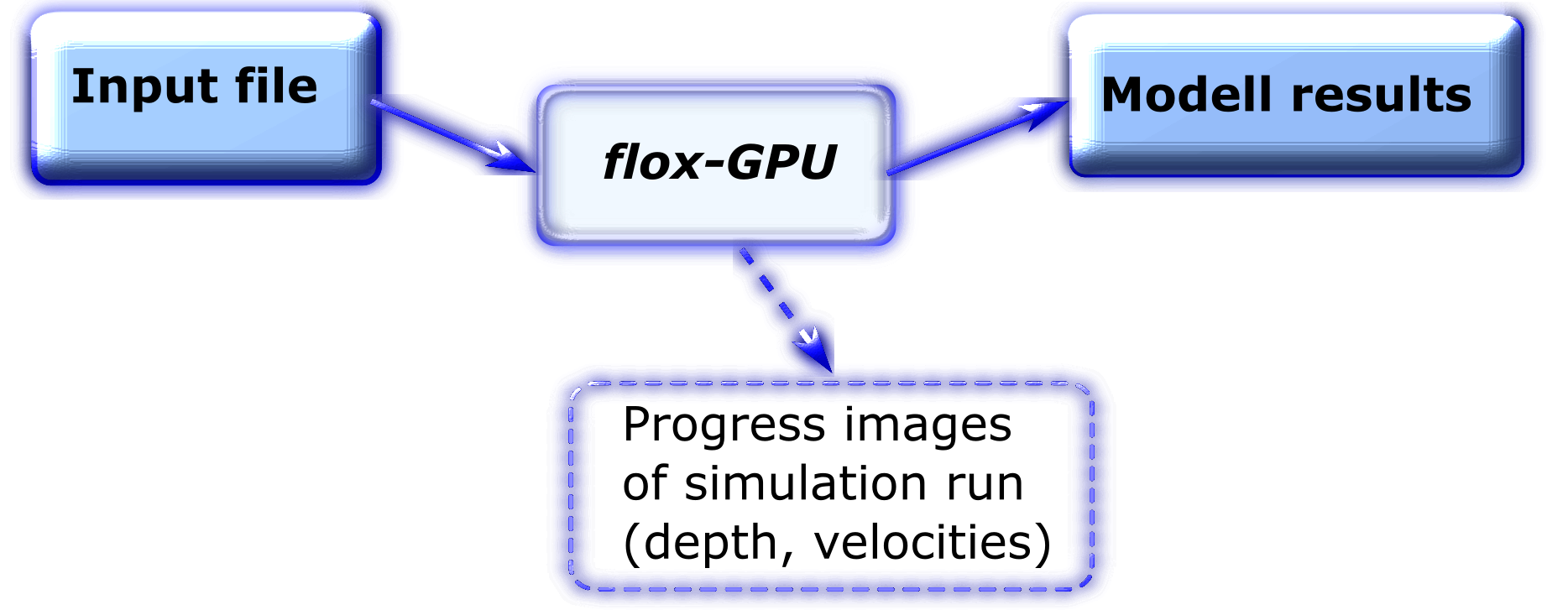 flox-GPU loads all input data specified in the input file and computes the unsteady 2D water flow within the given domain. This is done on a cell-by-cell basis. For high performance, dry raster cells are treated efficiently and no-data cells are excluded. Special care is given to the dry-wet-boundary typically moving ahead of a flood wave. During the computation flox-GPU keeps a record of the maximum flow depth, maximum velocity and maximum intensity (flow depth x velocity) on each cell. If desired, imagery of the simulation progress is provided.
Output:
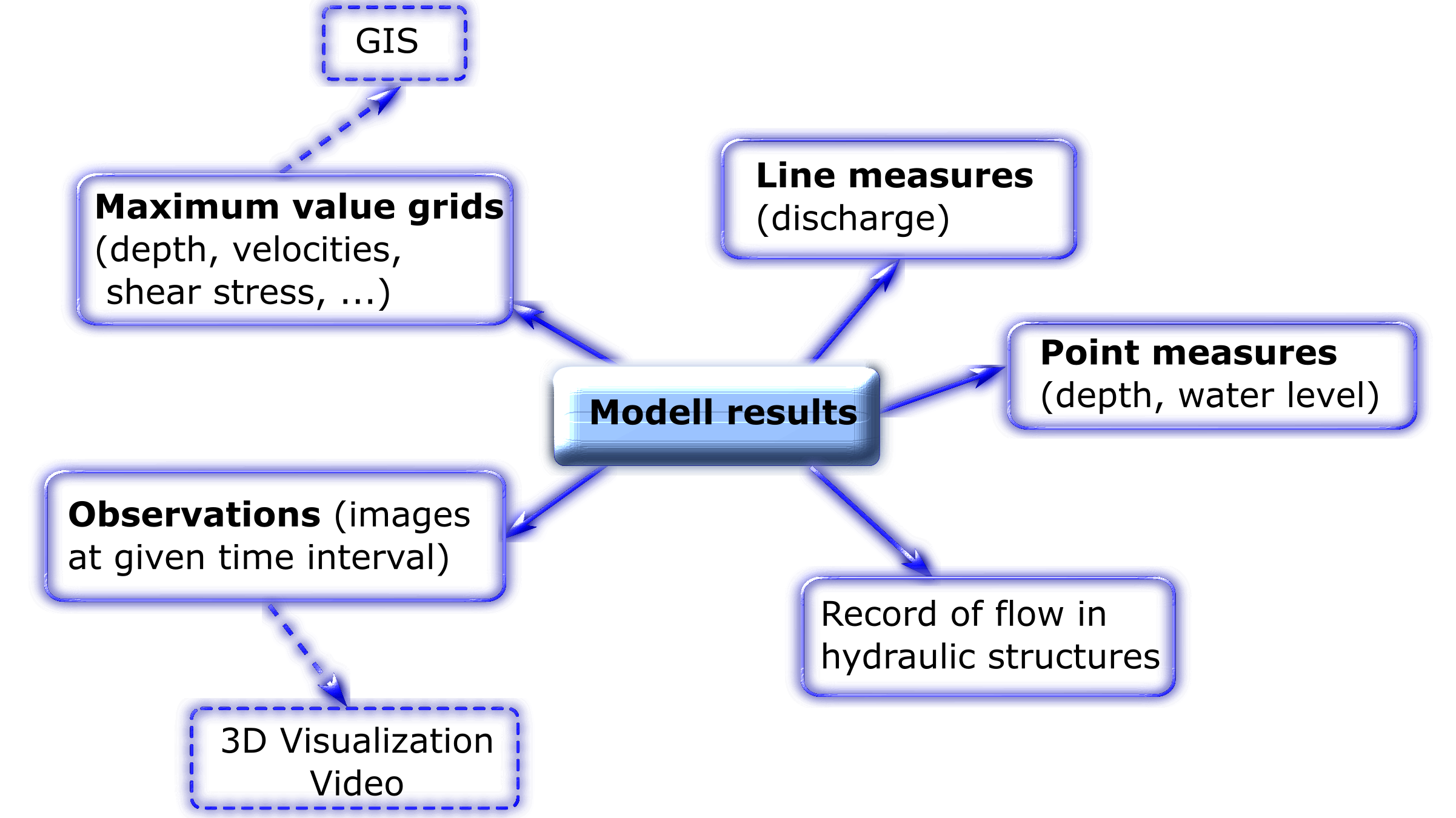 After completing the simulation, flox-GPU provides grids for maximum flow depth, maximum velocity and maximum intensity. If desired, additional results, such as energy level or maxmium shear stress, will be provided. Special areas of observation can be defined for detailed temporal output, point or line measures for discharge and depths can be placed in the grid and the flow behaviour at hydraulic structures is recorded.